Winter is over, but there are still many trips, vids, and pics that I’m planning on dragging out of the past to post. We’ll begin with this trip report from a few years ago. I wasn’t blogging then and wanted to go light, so no photo’s were taken. I was able to scrounge up some pics for use as visual aids.
I have a ski project’s folder on the computer with a list of objectives I’d like to try and what type of conditions, gear, etc, are necessary to safely achieve them. High on the list is what I’ve been calling the Wasatch Supercoaster Tour. The idea is to link up the biggest and steepest lines in the Wasatch in one day. With an extended high pressure and low avy danger it seemed like the perfect time to try it.
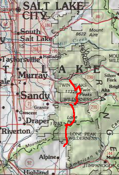
The Entire Route
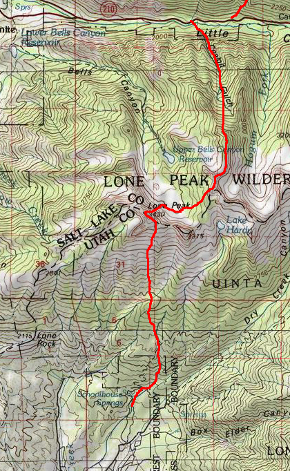
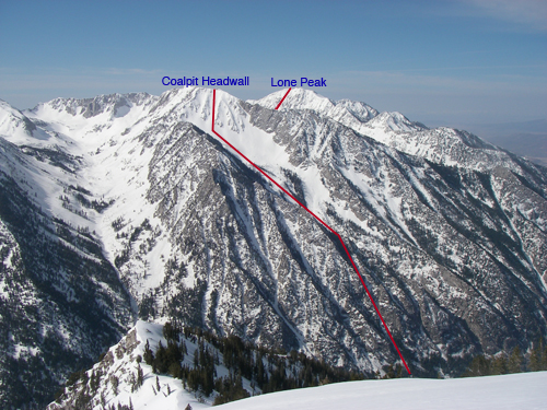
The Supercoaster Tour consists of two legs. The first section starts at the town of Alpine (Utah Valley) and climbs to the top of Lone Peak, ski the Northeast Face, continue up to and across Thunder Ridge and down Coalpit Headwall. This finishes in Little Cottonwood Canyon.
South Leg
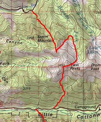
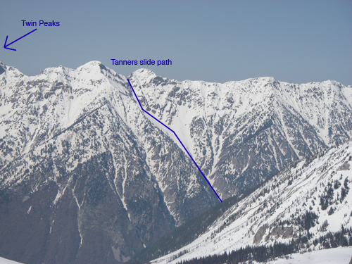
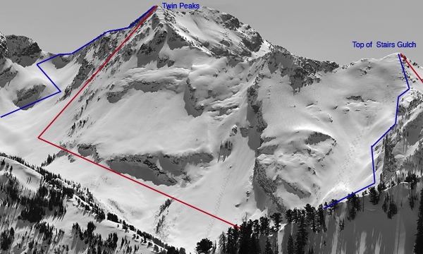
Leg two climbs Tanners slide path to Twin Peaks, ski descent of the East Face and continue to the bottom of Bonkers. Skin to the top of and descend Stairs Gulch to the Big Cottonwood Canyon road.
North Leg
Total elevation gain is over 14,000ft. I wanted to go as light as possible so I took a small pack with sunglasses, light shell jacket, headlamp, 10 packs of Gu, 3 clif bars, 2 nalgene bottles (one water/one cytomax). My quiver of skis was a little on the fat and heavy side so, I rented some Havocs and put my O1 bindings on them. Without a partner I left the probe, beacon and shovel behind.
On February 12th, 20006 my brother Jonah and his wife Ashley met me at 4am at the G.W. I. parking lot in LCC where I left my car and jumped in with them (just the way they wanted to spend their 4th wedding anniversary). According to the LCC info board, it was 14 degrees out and I was worried I wouldn’t have enough clothing, but that would be good motivation to keep moving. We drove to the trailhead in alpine where they dropped me off at 4:50am after lovingly letting me know I was crazy. Taking off in the dark, I knew the Supercoaster was really about one thing and that one thing is to keep moving.
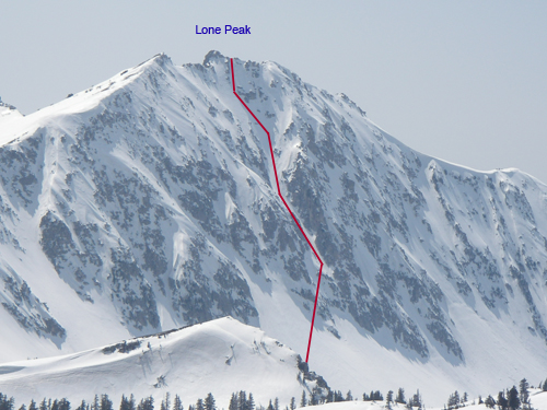
Not knowing how low the snow level would be, I started in light tennis shoes and went fast to warm up. The first little bit was dirt, then firm snow, which made for quick travel. I followed a snowshoe/skin track out of the first Hamongog, which bypassed the second Hamongog and headed up the big dished out drainage to the East. This track was firm and I went almost all the way to the summit ridge in tennis shoes. I took my first break and continued my Gu and Cytomax routine (every 45 mins). Someone had dug out a big bench that I used to switch from shoes to skinning, which my feet appreciated (they were covered in snow and frost when I took them out of my shoes). Once I hit the summit ridge, I was 2:30 in and feeling good. The ridge to Lone Peaks Summit is steep and exposed in the winter. Getting to the central couloir without whippets or an ice axe took a long time and was much more sporty than I had hoped. Once on the summit, I texted my bro and headed down the 50+ degree chute. The turning was great, soft windblown snow. Traversing out of the bottom, over the cliff, I noticed some tracks from a day or two before.
Descent route on Lone Peak
From Lone Peak to Coalpit was virgin terrain from me, but I had checked some maps and made my way towards the spot in the ridge where I thought I could get through. A cool half pipe type gully connected to a skin track that topped out exactly where I wanted to be. Keep moving I told myself! A quick traverse across thunder bowl led to a short boot pack that put me looking directly down the Dresden Face. Continuing to the top of Coalpit, I took a break and sent off another text message. It was 10am and I felt great. Despite many tracks in Coalpit, I still found some untouched consolidated snow that skied really well. My legs felt strong and I skied down with a couple of stops. The waterfall was easily passable using two semi-buried ropes on the skiers left side by the trees.
Descent routes on Lone Peak and Colpit Headwall
I made it to my car at 10:45, which was sooner than I had anticipated. Refueling on Gu and Cytomax and a slice of pizza I rested for 15 minutes and traded my tennis shoes for crampons. My original plan had been to head across the road and climb Lisa Falls to access Twin Peaks. However, my friend Dennis suggested Tanners (God bless you Dennis). Driving up the road a short bit would save around 1,000ft of climbing.
As I started up Tanners (11:10), the temps were warmer than I had hoped and I considered calling it off. The lower section is a huge terrain trap that sees large wet slides from above and from the sidewalls. I decided to haul ass instead. The heat made it tough but, tying my pants open and rubbing down with snow worked until a nice cloud cover moved in. In the narrow top of the chute a group of three were descending. They had put in a nice boot pack so I thanked them for it. Then what I thought was a rock falling off the ridge towards me turned out to be a Nalgene cozy somebody had dropped. The heat and the quickened pace was taking it’s toll at this point. I took a 10min break at the Broads Fork/Tanners notch (1:30). Keep moving!
Ascent route of Tanners Gulch
The few turns down from the saddle to the skin track were good. A quick skin to the next saddle turned to a boot and then a rock climb variation that kept me on the ridge, versus dropping in on the south side. Once on top, I took in the beautiful view and saw a group climbing back out of Deaf Smith after skiing the Northwest chute of Twins.
The East Face of Twins had been ravaged by skiers, but working the skiers right I found a lot of untracked snow that just got better and better. After some dreamy turns on the apron, I made a hard left and quickly traversed to the bottom of Bonkers (3:30). Passing by the ice cliffs, I noticed somebody had been hucking off of them. My guess is one of those damn film crews or photographers who think they own the place. It was nice to know this 2,000ft would be the last climb of the day. Mid way up Bonkers I was getting light in the head and started seeing things that weren’t there (tents). I must have really been out of sorts because I was actually thinking I could continue the tour by hitching up BCC and heading into millcreek and up Mt Aire and out to Parley’s Canyon. Maybe next time, but for now sanity and hunger won out.
Routes in Broads Fork below. The uphill is blue, the downhill is red. I snagged this screen grab from my buddy who goes by the Wizard of the Wasatch. He skis more than anybody I know and provides some great beta and avalanche reports on his site. Thanks Bob!
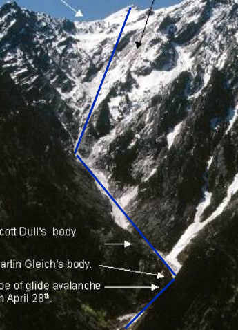
Topping out on Stairs I met a friend and his partner, they were the two I had seen in Deaf Smith Canyon. They asked where I had come from and I pointed to Lone Peak, which seemed like a long ways off. They looked a little confused and I’m not sure they believed me. Out of food and fading fast I asked if they had anything to eat. I already had my rocky mountain high, so I passed on the only substance they had to offer. We skied out Stairs Gulch (the longest and steepest avalanche path in the Wasatch) together, which had some good turns up high and some challenging snow down low. The legs were done for the day and not happy, they let me hear about it with every turn to the road.
The only photo of Stairs Gulch I could find, picture it with more snow.
The guys gave me a ride down to the 7-11 where I called Jonah, he dropped me off back at my car and told me I was crazy again.
As I drove home I was shaking from the cold and the lack of food, but smiling involuntarily at the pleasure of completing the Supercoaster.
Ascent- Over 14,000ft
Descent- Over 14,000ft
Time- 13 hours
Routes and ratings of descents-
Lone Peak NE Couloir (S5, 50 degrees, 1,400ft)
Coalpit Gulch (S4, 48 degrees, 4,930ft)
Twin Peaks East Face (S5, 50 degrees, 1,880ft)
Stairs Gulch (S4, 43 degrees, 4,800ft)

That was a solid day in the mountains –
Thanks Matt,
Still one of my favorite days in the mountains.
That is an insane route ive hiked lone peak in the summer and I have booted and skiid tanners. Both of them alone exhausted me. I cant even imagine how difficult this must have ben. Congrats on pulling it off.
First of all congratulation for such a great site. I learned a lot reading article here today. I will make sure i visit this site once a day so i can learn more.